![]()
|
Index
•
|
|
Welcome
•
|
|
|
The International Writers Magazine: USA Road Trips
The Badlands - One Fine Day
• Ari J Kaufman in American's spectactular heartland
On Friday morning, April 21, I found myself waking up to the piercing sun in a Days Inn hotel far, far from home. After filling myself with breads, waffles and bagels at the free continental breakfast, I checked out and began what would serve as the most intriguing, if not spectacular day of my week-long sojourn of our wonderful country's Rocky Mountain region.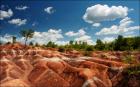
The trip had actually begun three days earlier in the rolling hills of the Midwest, from Chicago to Green Bay to Minneapolis and three-fourths of the way across South Dakota; but now, on the fourth day, the mountainous adventure would begin in earnest. As an added bonus in many ways, my girlfriend (Maria) had been able to escape the saunas and swamps of academic life in South Florida to join me back on the mainland, arriving in Minneapolis one day prior. She would be my companion, photographer, note taker and other things that have little do with travel, so this list will go no further.
Four distinct regions and destinations were on today's itinerary, with the National Parks of Northwestern Wyoming (Yellowstone and Grand Teton, of course) to follow over the weekend, before we returned home via Salt Lake City. We would start the day at the locally-famous Wall Drug Store in Wall, South Dakota, just four blocks from the hotel, then hit Badlands National Park, just seven convenient miles away for the rest of the morning, then scramble back onto Scenic Route 44 (through, you guessed it, the town of Scenic, South Dakota) northwest into Rapid City. At that juncture, we'd jump down into the Black Hills Forest, which would actually be an upwards jaunt since we'd climb to more than 7,000 feet to visit "The Boys" at Mount Rushmore. Finally, we'd finish up by exiting the snows of the Black Hills (a blizzard has occurred just 48 hours prior) into Wyoming and Devils Tower National Monument, about 35 miles North of I-90 in Northeastern Wyoming. With those boundaries and meticulous but flexible plans established, we entered Wall Drug Store just prior to 10am. They open at 6.30.
Wall Drug Store, taking up much of truly dusty Main Street in Wall, was built in 1931. There are cleverly placed and creatively scribed signs along I-90 West noting how many miles to Wall Drug from as far back as Southwestern Minnesota. South Dakota's portion of I-90 is nearly 300 miles before you hit Wall, so do the math to realize the magnitude of this little town's local legend.
The store was far more elaborate than I imagined. After all, it is a drug store, right? Founded by pharmacist Ted Hustead. Well, yes, about one-tenth of it is. The remainder of the store reminded me of some western shopping plaza in Scottsdale or Santa Fe, but much less yuppie and cuter. There were two souvenir stores, a few "western gear" stores, ring shops, statues, a chapel, two small restaurants with FREE ice and water (this sort of thing was a novelty back in the 1930s it seems) and a dinosaur exhibit somewhere in the back, which we never got around to seeing.
After purchasing our requisite souvenirs, Maria and I took a very agreeable road past I-90 and into the Buffalo Gap National Grassland toward Badlands National Park. The temperatur was unseasonably warm for this region, but pleasant for us in comparison to the humidity of April in South Florida.
As we approached the Badlands, seeing grass and fields on both sides of the car, I mused as to where these so-called "bad"lands were; however after passing through the park's gates, I was soon quenched. Along the entire duration of our two hours in the park, the right side of the rental car (that being the north side as we headed west) was covered in the relatively tepid greenery of grasslands with buffaloes roaming and prairie dogs sunning themselves. Doubtlessly, these rare animals were a nice diversion (after all, what good skeptic would actually be gullible enough to consider that buffaloes would actually inhabit the BUFFALO National Grasslands?), and when a hairy, squalid buffalo actually walked in front of our car (obviously he did not see the crosswalk), we scrambled to snap a cool photo.
However, the park's most authentic features were to our left, looking south out toward the grass tables, Bryce Canyon-esque canyons and vastness that one will only find in America's west. We hiked down the spongy dirt trails at the Hay Butte Overlook into the Badands a few times, but most of the time, Maria and I drove slowly and cautiously for 26 miles along the gravel -laden Sage Creek Rim Road that circumscribes the upper portion of the park within the Pine Ridge Indian Reservation. All in all, as we vacated the park at the aforementioned town of Scenic - which was depressingly anything but - the journey was worthwhile in the demonstrating the diversity and uniqueness that the Badlands displayed. A near 70 degree sunny day in April in South Dakota didn't hurt matters either.
After a 35 mile drive up and out of the farmlands, through construction and past a random dinosaur, we dined at Taco John's in Rapid City, the second largest city in South Dakota at 60,000 strong. Maria and I ambled our way up from sterile, urbane Rapid City and its 3,247 feet of elevation along the Mount Rushmore Highway down into Keystone (the touristy town that naturally enshrouds the historic monument, which thankfully was closed since we had not yet hit peak season), and then back up to the Mount Rushmore area at nearly 7,000 feet.
Why it is that businesses must take advantage of foolishly naive tourists and make tacky towns at the outskirts of historic areas? This is why Americans will never be considered as "cultured" as other societies.
Gatlinburg, Tennessee, just outside the Great Smoky Mountain National Park takes the proverbial cake, replete with space needles, wax museums and a Hard Rock Cafe. Nothing says "I took a great vacation" like a Hard Rock Orlando shirt and a snow globe with a tiny replica of Downtown Branson, Missouri in it. Well, sadly to most Americans, that is the epitome of uber-uniqueness in travel. This all really pains me to admit as a patriotic American, but 90% of us, from our coastal elites to our Middle American heartlanders need a lesson in enjoying their continent. Boca Raton, Honolulu and Cancun simply do not count.
Much as travel writer Bill Bryson once noted while looking a beautiful and empty villa in the island of Capri, "It's a shame that wealth is wasted on the rich." It truly is, Bill. And with that, let's now move on to the pine tree-laden, frosty peaks of Mount Rushmore in rural South Dakota, a perfect example of a fantastic marvel that the majority of Americans will never see with their eyes, aside from when watching Superman or Austin Powers movies.
As you climb from the town of Keystone to the monument that pays homage to four of America's greatest presidents, the roads are windy, hilly and, thanks to the recent blizzard in the region, full of a mixture of white powder and verdancy. It's not the bucolic setting of the Badlands or the farms of the Midwest hills we saw earlier, but to me, this area was more majestic.
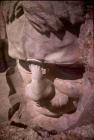
The Mount Rushmore National Monument was built between 1927 and 1941 after the idea was proposed by Gustav Borglum and introduced to congress by President Calvin Coolidge in 1923. On this very warm spring day that still radiated winter, it appeared to a no-brainer to build this memorable marvel to view.
Maria and I walked by a sculpture of Mr. Borglum, which was erected by his son, Lincoln, and stands as an entry point the walkway that leads to the Grand Terrace where we could catch our initial glimpses of the heads of the presidents, craved out of the stony mountain. The walkway itself is pristine and immaculately lined with the state flags of each United State, replete with the year of its inception. I rather enjoyed this a bit too much.
One thing that pleasantly surprised me within my first observations of the monument - perhaps induced by the snow and aforementioned greenery - was how lush the areas around the mountain are. Not only were the areas just below the heads full of snow and pine, but the views of the surrounding areas below and behind us were dotted with snow and hills that resembled the Rocky Mountains more so than what we'd recognize as the Black Hills of Western South Dakota. Most images of Mount Rushmore leave the viewer with the thought that the monument is out in the desert or canyons (perhaps the Badlands) but this is false, and perhaps enhanced by the fact that most photos are taken in summertime. Below the monument is also an exquisite amphitheatre with a breathtaking view of the hills and heads above. (Sadly, I never ascertained how often it is used, nor for what purpose.)
While most other viewers decided that the Grand Terrace view was enough for their money and time on an unusually warm 65 degrees and sunny late afternoon, Maria and I decided to "hike" the 1.2 mile, rail-enclosed loop trail up and around the monument. It wasn't exactly strenuous, although the only other people we saw on it were fit-looking Europeans. Most Americans proceeded to the gift shop to undoubtedly buy a plastic replica of Abe Lincoln's head. Whoops, I did that later too!
But the trail was unique in that it offered a view of each solitary presidential dome at certain points, with of course a plaque detailing each president's accomplishments and biography when a gaze at his head only. Many would ponder how Teddy Roosevelt came to have his cranium emblazoned alongside arguably the three most important leaders in US history, but when you consider his leadership in the Spanish American war, his environmental industriousness, and that his presidency truly launched us into the 20th century (TR was the first US leader to travel abroad in 1901), his placement is justified. And being that this 660 foot monument was dedicated in 1941, there aren't any other presidents who jump to mind that were missed, aside from perhaps Ulysses S. Grant, Woodrow Wilson or James Madison. Arguably, if another four were added today, you would find Franklin Roosevelt, Dwight Eisenhower, Harry Truman and Ronald Reagan, but that's a discussion for another time. Instead, a new monument to Native American war hero, "Crazy Horse" is being erected.
-450,000 tons of rock were removed from Mount Rushmore to leave space for the four faces.
-90% of the rock and granite was removed via dynamite, with the remaining extracted by way of jackhammers and wedges to knock the rocks from the mountain.
-It is reported that George Washington, and we presume the others are similarly endowed, has a head that is 60 feet tall, a nose that is 21 feet long and a mouth that is 18 feet wide.
As we left, and I snapped a photo of the breathtaking, Southern Utah-esque horizon from the top of the parking structure, the only words that came to my mouth to honor this man-made achievement were, "That was quite a thing." It is indescribable unless you see it with your own eyes.
The drive down from Mount Rushmore, on Highway 244 West and then 385 North near Custer State Park did not disappoint; in fact, it was the biggest surprise of the trip.
I had half-expected to come out of the hills to a flat state highway which would then deposit me along I-90 in the town of Spearfish, just a dozen miles or so from the Wyoming border, which I knew was tundra-like, although at 5,000 feet of elevation. Instead, we drove along patches of snow, over bridges high above breathtaking Sheridan and Pactora Lakes, until we smoothed out into the charming town of Deadwood, South Dakota.
The blizzard from roughly 48 hours ago had dropped up to 34 inches in some parts of Deadwood and nearby Lead, but now the roads were slushy and the snow was piled high along the sides, making driving only moderately difficult. Surely, the road we had entered on outside the National Forest had been closed as recently as 24 hours ago.
Forty miles north of Rushmore, 30 miles northwest of Rapid City and about 11 south of I-90, Deadwood is the official "resting place of Wild Bill Hickok." It is a cute cowboy/mountain town, resembling the scenery of Telluride, Colorado, but thankfully lacking the yuppie stores, and instead dotted with a courthouse square and white houses in the hills that resembled dollhouses, according to Maria.
We drove down Pioneer Way, noticed the amicability of the locals as we had a quick bite, the drove the dozen or so miles to the interstate in Spearfish. As I expected, now that we had officially left The Black Hills Forest, we were soon on a flat road in the "tundra" that more resembled images of Antarctica or Finland than the Wild West.
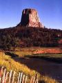
It was now nearly 6pm, but the sun was still high and brilliant above us, and temps had still not yet dipped below 60. We proceeded to Devils Tower National Monument in Northeastern Wyoming.
The Tower is located about 13 miles into Wyoming, and then (at least when coming from the East) about 22 miles northwest of the Wyoming town on Sundance, along the sweeping terrain of US-14.Devils Tower was once an important landmark for Plains Indian tribes in Wyoming. Its first documented visitors were members of WF Reynolds Yellowstone Expedition in 1859. The current name was coined in 1875 by a US Geological Survey Party. Devils Tower was christened as the nation's first national monument in 1906, and this "rock climbing mecca" was first conquered in 1893, although the first technical rock climbing was not done until 1937. Today, hundreds of climbers make their way 1,280 feet to the top each summer, although it looks extremely difficult to be frank. Climbers must register with a guide before even attempting the journey. How did I know this? I can thank the "historic" information sign about three miles before Devils Tower.
As you approach Devils Tower, even more so than Mount Rushmore, it seems to be all around you at all times. The landscape here is hilly but not extremely mountainous, thus even though the road swerves, you can see the Tower 99% of the time as you approach it along the 22 miles from the interstate.
Maria and I, arriving at about 640pm with at least an hour or more of good daylight left, decided to hike the 1.3 mile trail around the base of the rock. Figuring it would be docile terrain and at most a 35-40 minute jaunt in sunlight, I eschewed putting on a sweatshirt and we ventured off. Big mistake.
As we ventured two or three tenths of a mile into the loop, the snow began to cover most of the trail, and with the sun rarely hitting this side of the monument, the land was indecipherable. Not only this, but the temps were dropping as fast as the sun. The trail reappeared at time, but mostly we just tried to walk in a circle as quickly as we could around the tower, hoping for the bulk of the sun to reappear, alerting us that we were almost back around.
At about 7.30pm, with temps now in the upper 50s at best, and the sun continuously fading fast behind the mountains, wearing a t-shirt and recalling that no other cars were in the lot when we pulled in, we were a tad worried. Upon seeing a sign indicating that we were only halfway done with the trail, Maria and Ari had to decide whether to turn back or keep going. Either way, we had a minimum of 20 minutes to go, but who knew how the snow would be the rest of the way. We pressed on. (If you look at the photos of Devils Tower here (then imagine it is snow and donning only a t-shirt and jeans), you can tell it's not like a night at the Sheraton, or even the Days Inn for that matter.)
The snow did not clear up until the latter quarter-mile of the hike, but we made it down at about 7:50pm with scarce light in the air. As I sit here in the 90 degree sun of South Florida, I can laugh about it, but it was no laughing matter five days ago.
After reaching our hotel much later that night, Maria and I enjoyed our remaining two day of the trip in Yellowstone and Grand Teton National Parks. Those were remarkable as we would expect, but this "one fine day" in the Black Hills Region of our country is a hidden wonder that needed to explored, and I hope that others will do so too.
For more on Badlands National Park
For more on Mount Rushmore, please click here.
For more on Devils Tower National Monument, please click here.
© Ari Kaufman May 2006
ajkauf7@yahoo.com
Driving Deep South
Ari Kaufman -USA
More World Destinations in Hacktreks
Home© Hackwriters 1999-2006
all rights reserved - all comments are the writers' own responsibiltiy - no liability accepted by hackwriters.com or affiliates.